As a global meteorological outpost, the mechanism and influence of climate change on the Qinghai-Tibet Plateau are complicated. In October 1998, I led the “Yarlung Zangbo River scientific rafting expedition”, drifted 1,600 kilometers from the Jiemayangzong Glacier in Zhongba County, Tibet, the source of the Yarlung Zangbo River, to Pai Township (today’s Pai Town) in Mainling County. After that, I crossed the Grand Canyon on foot and spent 35 days crossing the Yarlung Zangbo Grand Canyon. In 2010, I launched another bold project, “Asian Water Tower — International River Survey on the Qinghai-Tibet Plateau” and spent six months visiting a majority of international rivers on the Qinghai-Tibet Plateau. Although I had explored most of the rivers on the Tibetan Plateau over the past 20 years, in this mission, we did a systematic, complete, inch-by-inch survey of the headwaters of Asian great rivers that originate on the Tibetan Plateau.
During the investigation, I felt the benefits that the implementation of the River Chief System in recent years has brought to the protection of both water resources and the relevant environment on the Qinghai-Tibet Plateau, and I could clearly see the efforts of climate actions such as the layout of clean energy and de-coaling. But the unprovoked accusations, such as artificial rainfall on the Tibetan plateau, are always discouraging. Regardless of the standpoint of science, the well-rounded artificial rainfall, as a very scientific and rigorous scientific practice, has been used in the United States, Australia and other countries. However, many people still believe that artificial rainfall is to release some cold air into the clouds. The most important fact is that the Tibetan Plateau region of China has a small population and the natural ecology has been able to meet the need of local living conditions. Therefore, large-scale artificial rainfall has no practical application scenario and practical significance at all. To top it all off, some people believe that China is just competing with India for rainwater.

I have heard similar rumors and prejudices at many South Asian Non-governmental organizations’ symposium on international rivers. Most of the participants remarked, “It is amazing how little the media of each country knows about its neighbors.” In this environment of lack of communication and political suspicion, debate is often driven by lack of information and political smear, and alarmist media reports are more likely to fan the flames of national conflicts.
There has always been controversy around the discussion of climate change, especially the various claims of the scientific interpretation of the mechanism of climate change. What is even more puzzling is that negotiations on climate action, without strong scientific support, seem to only strive for profit, and humanity will lose its way if it continues like this. The scientific community has long believed that the Qinghai-Tibet Plateau is the frontier of the earth science, with many key issues to be broken through. Tackling climate change will be futile or even disastrous before it is solved.
Over the last 2.6 million years, Earth’s climate has fluctuated between cold and warm periods – glacials and interglacials – characterised by the growth of major ice sheets over the Northern Hemisphere continents during cold periods and their retreat during warm periods. The Tibetan Plateau, which is known as the world’s Third Pole, is extremely sensitive to climate change. During the last deglacial period (starting from the Last Glacial Maximum, approximately 21,000 years before present), the area covered by land ice retreated from 30% to 11% of the Earth’s total surface area; the sea level rose by about 130 m and China’s coastline receded by about 600 km. The Mid-Holocene, roughly 6,000 years ago, was the warmest period during the last deglacial. The global mean temperature was 2-3 ℃ higher and the sea level was 1-3 m higher than their values today. The Little Ice Age was a period of cooling that extends from the 15th to the 19th centuries, with glaciers advancing extensively. Is the global warming today a start of a warm period?
Most rivers on Qinghai Tibet Plateau belong to the glacier- source rivers, Yangtze river and Yellow River in China originate here; the Ganges river, Indus river, Brahmaputra River (called the Yarlung Zangbo River in China) in South and Southeast Asia originate here; the Mekong River (called Lantsang River in China), the Salween River (called Nujiang River in China) originate here; the Irrawaddy River (called Dulong River in China) originate here; the Tarim River and the Qaidam River in northwestern China originate here; and the Syr River and the Yili River in western Asia also originate here. These rivers feed billions of human beings. They are the rivers of our human life!
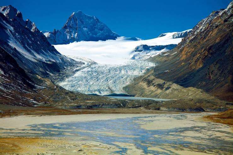
Global warming is causing glaciers and ice sheets to melt faster and in turn a series of natural disasters and the water crisis. Recent researches suggest that sea level rise induced by melting of ice in the cryosphere of polar regions is a threat to the safety of island and maritime counties. Moreover, the cryosphere of the Tibetan Plateau is very sensitive to climate change, which is characterized by increased surface temperature, decreased rainfall (snowfall), higher snow line, retreated glaciers, less complex river systems, expanded deserts and more frequent extreme weather events such as floods and mudslides resulted from break of headstreams associated with glaciers. We feel worried about the warming at the altitude of 5500m.

Glacier ruptures around the Qinghai-Tibet Plateau have occurred frequently in recent years. The most recent one occurred on February 7, 2021, in Uttarakhand state of India. The ruptured glacier fell into the Alleghenda River, causing the river to burst its banks and at the same time causing the huge floods. It is true that India has a lot of room to improve its natural disaster warning system, but it is global warming that is to blame for this tragedy.
What are the main causes of climate change and glacier melting on the Qinghai-Tibet Plateau? In recent years, some researchers have suggested that when the solar system moves out of the Quaternary Ice Age and into a higher background energy field, it is the cause of the temperature rise. However, I believe that the temperature rise at the altitude of 5,000 to 6,000 meters is mainly caused by the fact that a large amount of greenhouse gases emitted by human beings absorb heat in the atmosphere of the Tibetan Plateau in the atmospheric circulation. Therefore, we should face and share the responsibility together instead of making groundless accusations against any one country in order to deal with climate change on the Qinghai-Tibet Plateau and even over the whole world.
Vice President of the United States Harris pointed out recently, the war for water resources will come soon. In my opinion, both water resources and the influence of global warming on the Tibetan Plateau are a fait accompli, the unilateral effort of each country is only a temporary solution. Environmental protection is not just a matter of pure science, but if there is too much political manipulation and rancour involved, the problem gets trickier. The growth of all creatures depends on harmony. China and south Asian countries around the Tibetan Plateau create a new win-win cooperation of climate governance in such aspects as scientific research, the meteorological disaster warning, can not only monitor the secondary disasters caused by climate change, to avoid the life and property loss. More importantly, a collaborative and vivid climate action can provide the international community with a set of effective experiences that can be replicated in climate governance.
Climate change is already causing serious environmental problems on the Tibetan Plateau and the Brahmaputra River basin as I have proposed many times in international seminars. The international community should build consensus and join hands in tackling these threats especially the neighboring countries. Partha J. Das, a scientist from the Indian NGO Aaranyak, also pointed out at the symposium that these warnings apply to the Indian government as well. The Indian government plans to build 70 water projects on the upper reaches of the Brahmaputra River. China and India need face the common threats in cooperation. Referred to the outburst floods from the upper reaches of the Brahmaputra in June 2000, Das said: “Most of the damage could have been avoided if the media in both China and India had reported it widely.” Obviously, China and India are both on the same page at environmental and climatic changes on the Tibetan Plateau. He also claimed that China and India should enhance cooperation on flood early warning both in the Government and Non-governmental, signing a bilateral agreement and sharing hydrological observation data.
Author: Hengduan Mountain Research Society


